■Gathering Environmental Data in the Lake Biwa Basin
Lake
Biwa water environment survey including submerged plant
observation
Submerged plants are essential in ensuring
the well-being of Lake Biwa as well as providing habitats
for other living creatures. They therefore function as the
core of the Lake Biwa shores ecological system. To assess
the water level fall impact on living organisms and creatures,
basic biological information capable of serving as a reference
for Incorporated Administrative Agency Japan Water Agency
must be gathered. Thus submerged plants for the whole area
of Lake Biwa are thoroughly investigated during the summer
once every few years.
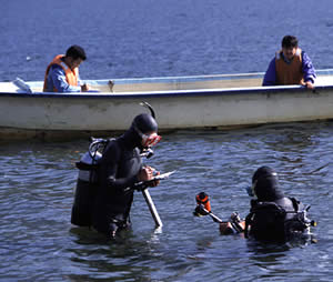
Survey
points and investigation method
●
Diver observation along 109 traverse
lines in Lake Biwa.
●
For survey purposes, an anchored rope
is laid on the bed of the lake, extending from the base
point provided at the shore to an offshore point demarcated
by the lower limit of vegetation for submerged plants.
This serves as a traverse line for surveying.
●
The traverse line position is determined
by measuring latitude and longitude using GPS (Global
Positioning System) from the base point at approximately
200 meter intervals.
●
Considering an area measuring 10 m
along the anchor rope and 2 m wide as a block (20m2),
divers continue to observe visually until the lower
limit of vegetation for submerged plants can be confirmed.
Diver
survey procedure
Water
depth
100%
of block area
90% of block area
・
・
10% of block area
Sparse (1%)
None (0%)
A ruler or a bathometer is used
to measure water depth up to 0.1 meter and the measurements
converted into B.S.L.
Vegetation
coverage ratio
Submerged plant projected areas
against the block area are categorized in 10% increments
and rankings recorded.
Copyright(c) 2003 Incorporated Administrative Agency Japan
Water Agency Lake Biwa Development Integrated Operation & Maintenance
Office All Rights Reserved.