Map of the River Basin
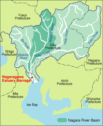
The Nagara River has a basin area of 1,985 km2 with the mainstream 166 km long.
It originates in Mt. Dainichigatake at an elevation of 1,709 m in Gujo City, Gifu Prefecture. It runs southeast and further south while joining the Kibishima River, a tributary on the right, and the Yoshida River on the left. After joining the Itadori River on the right in Mino City, it turns southwest and joins the Mugi River on the right and Tsuho River on the left upstream of Gifu City. It flows south via Gifu City, joining the Ijira River on the right. It joins small tributaries such as the Itonuki River and Arata River and reaches Sunomata.
The Nagara River meets the Sai, Sakai and Kuwabara Rivers, flows parallel to the Kiso River with a high-water levee separating the two from the southern end of Hashima City. At the south end of Kaizu City approximately 10 km downstream, Fukuhara waju (circle levee) and Nagashima waju are located between the Nagara and Kiso Rivers. The Nagara River runs along the Ibi River with a separating levee on the right bank. It meets the Ibi River in Kuwana City, Mie Prefecture at its mouth and empties in Ise Bay.
The Nagaragawa Estuary Barrage is located 5.4 km upstream of the mouth of the river.