
Introduction of facilities > Imagiregawa Estuary Barrage
Imagiregawa Estuary Barrage
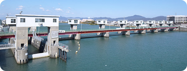
The Imagiregawa Estuary Barrage is built between Tainohama, Kitajima Town (on the left bank) and Enokize, Kawauchi-cho (on the right bank). The surrounding areas are remarkably urbanized with factories, houses and large suburban shopping centers. This estuary barrage consists of one lock gate to let ships through, six water control gates, one regulating gate and two fishways on the right and left sides. The Kyu-Yoshinogawa Estuary Barrages Management Office is just next to this barrage, located in Kawauchi Town.
| Location | Right bank | Enokize, Kawauchi-cho, Tokushima-shi, Tokushima |
|---|---|---|
| Left bank | Tainohama, Kitajima Town, Itano-gun, Tokushima | |
| Estimated high-water level | T.P. + 3.277 m | |
| Estimated high-water discharge | 1,100 m3/sec. | |
| Barrage length | 220.3 m (movable part: 206.3 and fixed part: 14.0) | |
| Barrage height | T.P. + 1.767 m | |
| Foundation height | T.P. - 4.233 m | |
| Water gate length | 193.3 m | |
| Water gate | Gate | Flood control gate 1 over flow shell type double leaf wheel gate 25.0 m in span x 6.0 m in height Regulating gate: 6 steel shell type wheel gates 25.0 m in span x 6.0 m in height |
| Lock gate | Effective width x length |
7.3 m x 36.0 m |
| Gate | 2 wheel gates 7.3m in span x 6.0m in height |
|
| Fishway | Gate | 2 flap gates 5.5 m in span x 1.812 m in upright height |
![]()
![]()
![]()