|
The
scale of Lake Biwa |
 |
|
 |
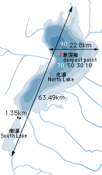
| Lake
Area |
Approx.674km2 |
Approx.
1/6 of the area of Shiga Prefecture |
| Max.
Length |
63.49km |
The distance
from Shiotsu, Nishiazai-cho to Seta, Otsu
City |
| Max.
Width |
22.80km |
The distance
from Shimosakahama-cho, Nagahama City to Aiba,
Shinasashi-cho |
| Min.
width |
1.35km |
The length
of Lake Biwa Bridge |
| Shoreline
Length |
Approx.
235km |
Almost
equal to the distance from Otsu to Hamamatsu |
|
|
|
 |
|
|
The
depth of Lake Biwa |
|
|
|
| Water
Surface Altitude |
T.P.+84.371m |
O.P.B.85.614m
Biwako Basic Surface Water Level (B.S.L.±0.00)
has almost the same altitude as the
Osaka Castle Tower |
| Lake
Capacity |
Approx.
27.5 billion m3 |
Approx.
1000 times as much as the Amagase Dam |
| Max.
Depth |
103.58m |
The
North Lake: Approx. 43m (avereage)
The South Lake: Approx. 4m (average). |
|
|
|
|
| T.P.:The mean sea-level
of Tokyo Bay O.P.B.:The
mean sea-level of Osaka Bay |
|
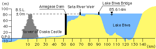 |
| B.S.L.=Biwako Basic Surface
Water level |
| Top▲ |